Vermont's 5 best road trips
TripFalcon September 23, 2020
Last Update: 2020-09-23 10:24:59Whether seen under blankets of snow, patchworks of blazing fall leaves or the exuberant greens of spring and summer, Vermont's blend of bucolic farmland, mountains and picturesque small villages make it one of America's most appealing states. Here are five destinations to venture out to for a truly scenic road trip.
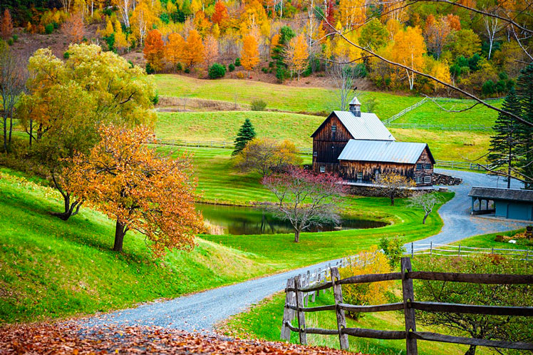
Green Mountain Byway
Following Vermont's Green Mountain spine through the rural heart of the state, VT-100 rambles past rolling pastures speckled with cows, tiny villages with country stores and white-steepled churches, and verdant mountains crisscrossed with hiking trails and ski slopes. It's the quintessential side trip for those who want to slow down and experience Vermont's pastoral essence.
The road runs north to south all the way from Massachusetts to Canada. Even if your time is limited, don't miss the scenic 45-mile stretch between Waterbury and Stockbridge, an easy detour off I-89. For details about attractions along the way, visit Vermont Byways.
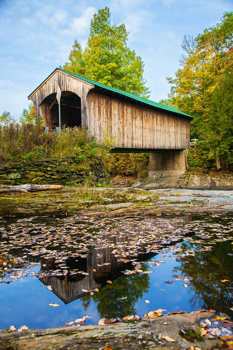
A road trip to any of Vermont's covered bridges is always a good idea © Bob Pool / Shutterstock
Covered bridges
Vermont has more covered bridges per square mile than any state in the union.
Northfield Falls (northern Vermont): This small town 8 miles south of Montpelier has a unique claim to fame: three covered bridges in a row! Turn west off VT-12 onto Cox Brook Rd and you'll see Station Bridge, Newell Bridge and Upper Bridge – all within a few hundred feet of each other.
Montgomery (northern Vermont): This village, which is 9.5 miles from Berkshire, has a whopping seven covered bridges, more than any other town in the state.
Windsor (central Vermont): Spanning the Connecticut River from Windsor, VT, to Cornish, NH, the 449ft Cornish–Windsor Bridge is the longest historical covered bridge in America still open to automobile traffic.
Bartonsville (southern Vermont): The original 19th-century bridge was famously swept away in Hurricane Irene's floodwaters in 2011. But in classic Vermont fashion, locals rallied to have a replica reconstructed. The bridge reopened to the public in January 2013. It's 7 miles northeast of Grafton on VT-35N.
Nothing like a road trip to quiet Vermont town that seems frozen in time © Thomas h. mitchell / 500px
Villages frozen in time
Many Vermont villages have a lost-in-time quality, thanks to their architectural integrity and the state's general aversion to urban sprawl. Some, like Grafton, Newfane, Woodstock and Dorset, are well-known to outsiders. Others are further off the beaten track.
Brownington: This sleeping beauty 40 miles north of St Johnsbury is full of 19th-century buildings reposing under the shade of equally ancient maple trees. The Old Stone House Museum here pays tribute to educational trailblazer Alexander Twilight. The first African-American college graduate in the US, he built Brownington's boarding school and ran it for decades.
Peacham: This idyllically sited village 15 miles southwest of St Johnsbury was originally a stop on the historic Bayley–Hazen Military Rd – intended to help Americans launch a sneak attack on the British during the Revolutionary War. These days it's just a pretty spot to admire pastoral views over the surrounding countryside.
Plymouth Notch: President Calvin Coolidge's boyhood home, preserved as the President Calvin Coolidge State Historic Site, looks much as it did a century ago, with a church, one-room schoolhouse, cheese factory and general store gracefully arrayed among old maples on a bucolic hillside. It's 15 miles southwest of Woodstock.
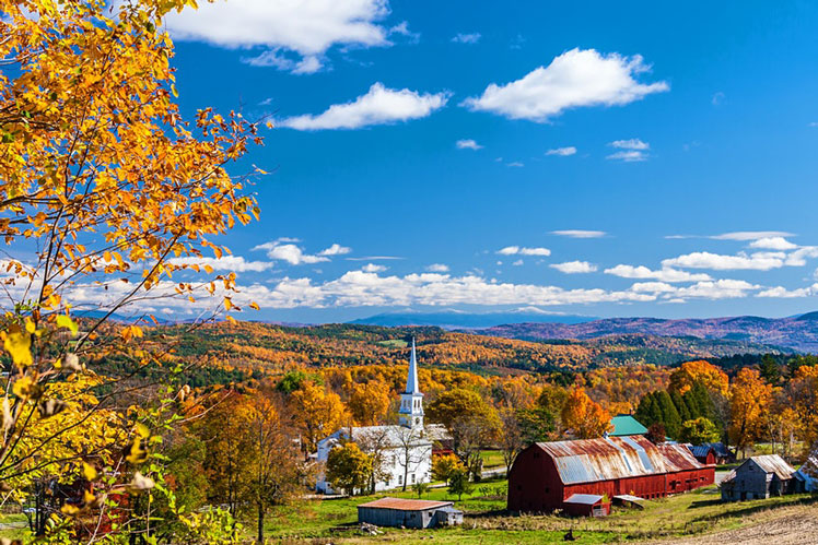
No Vermont road trip is complete without a little leaf peeping © Tom Narwid / Getty Images
Leaf peeping
Grafton: Villages don't get any cuter than this. Grafton looks like it was airlifted in from an earlier century. The white clapboard buildings are even more photogenic when contrasted against fiery leaves and a brilliant blue sky. Grafton lies at the junction of VT-121 and VT-35, about 27 miles north of Brattleboro and 45 miles southeast of Manchester.
Mt Mansfield: Vermont's highest peak is gorgeous when draped in fall colors, especially when an early snowfall dusts the summit white. The best panoramic perspectives are from Stowe (VT-108 N; 9 mi), Jeffersonville (VT-108; 8.2 mi), Cambridge (VT-108; 11.8 mi) and Underhill (VT-15 E, VT-108; 20 mi). Hikers can also experience the full sweep of color from the mountaintop; one of the prettiest routes is the Sunset Ridge Trail in Underhill State Park.
Merck Forest: Climb to the barn meadow at this environmental education center in southwestern Vermont for breathtaking vistas of the Taconic Mountains in bright rainbow colors. The park's centerpiece is a working organic farm with animals, vegetable gardens, renewable-energy installations and a sugar house where you can watch maple syrup being produced during sugaring season. It's hidden away on a gorgeous hilltop, only 25 minutes from busy VT 7 but a world apart from Manchester's designer outlet hustle and bustle.
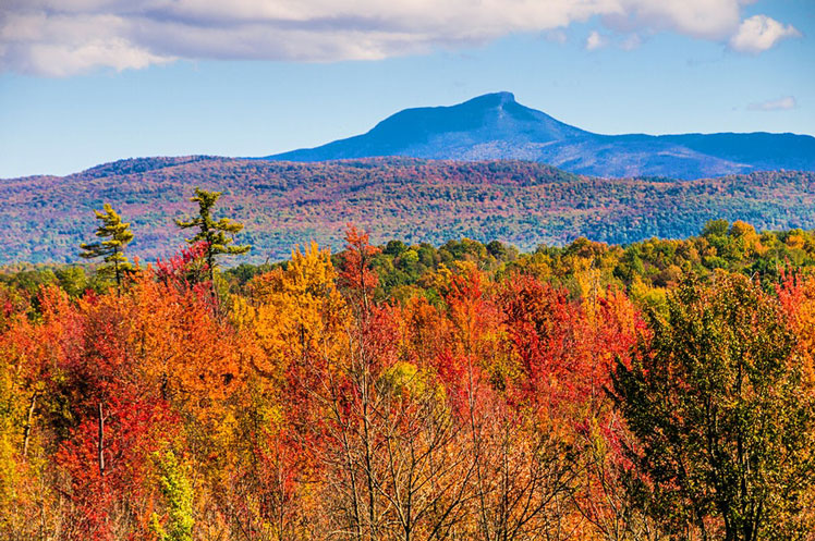
Camel's Hump is the state's third-highest mountain at 4083 ft © Ken Wiedemann / Getty Images
Camel’s Hump
The state's third-highest mountain – is a familiar image to Vermonters: its silhouette is visible on the Vermont state quarter, from suburban Burlington and along I-89. Yet it remains one of the state's wildest spots, one of the few significant Vermont peaks not developed for skiing.
To get here, detour south off I-89 at Richmond (between Burlington and Waterbury), take US 2 east to Richmond's main stoplight, then drive south 10 miles to Huntington Center, where you'll turn left (east) 3 miles, dead-ending at the trailhead for the 6-mile Burrows–Forest City loop to the summit. After climbing through forest, the final ascent skirts rock faces above the tree line, affording magnificent views.

Search
Social Media
Recent Articles
10 beautiful hotel pools around the world for 2024
TripFalcon March 09, 2024
Walt Disney World has raised ticket prices for 2025
TripFalcon March 09, 2024
Nepal to require all Mount Everest climbers to use a tracking chip
TripFalcon March 09, 2024